County Fire in Yolo County now at 32,500 acres, 2 percent contained

BROOKS, Calif. (KGO) -- Cal Fire is battling a monster fire in Yolo County which exploded in size overnight. Red Flag fire conditions didn't help more than 1,000 firefighters battling the 32,500-acre County Fire in Yolo County Sunday. Cal Fire says the blaze is now 2 percent contained.
It has now moved into Napa County towards Lake Berryessa.
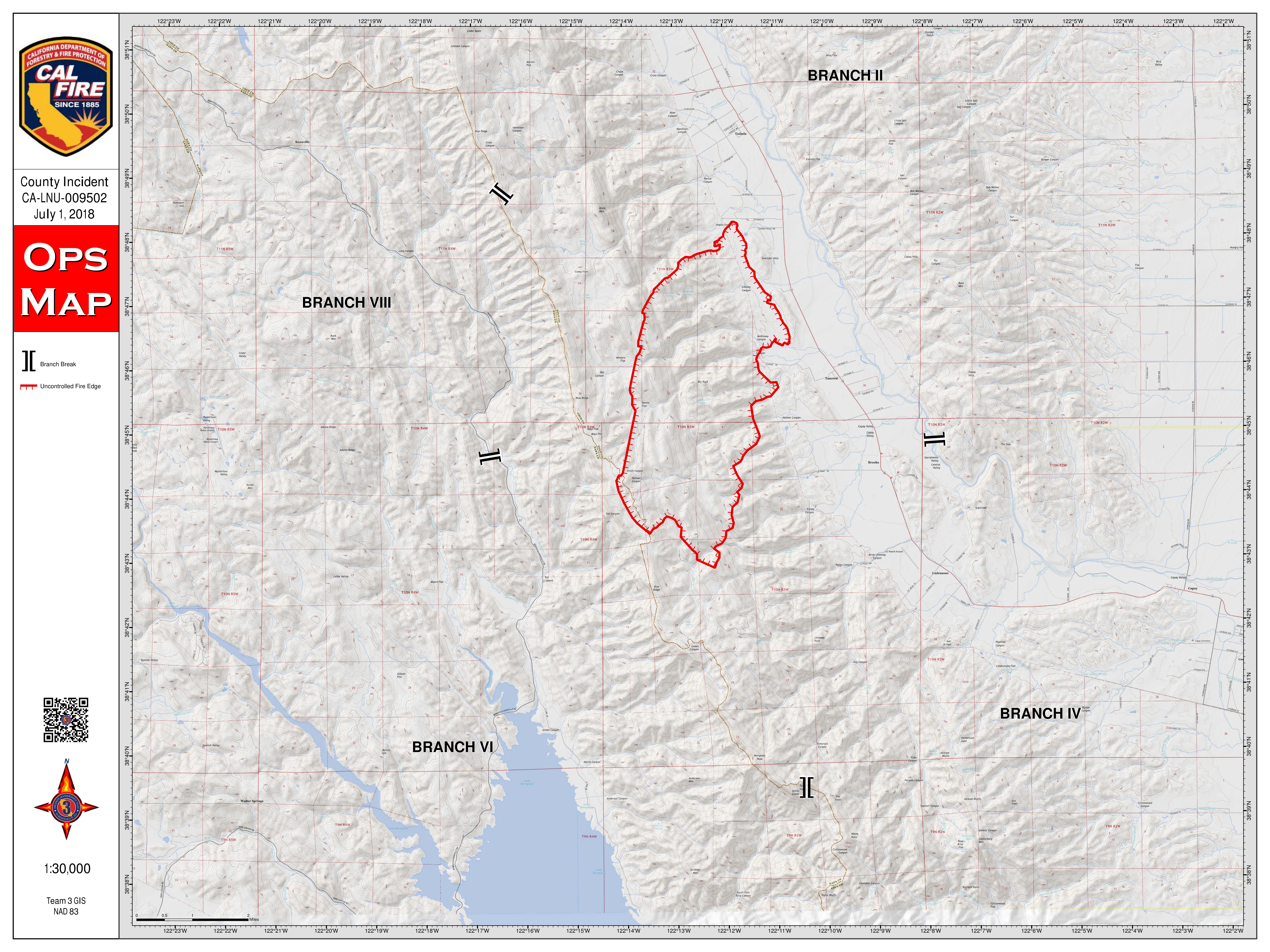
MAP: A look at the 'County Fire' in Yolo County
"We knew coming into this weekend that we were going to have very hot and dry weather conditions and we've been under a Red Flag Warning now for most of the weekend," said Cal Fire spokesperson Chris Anthony.
That's what they got, and now those brutal conditions are working against fire crews.
Scorching hot temperatures and gusty winds proved challenging for fire crews. Fire helicopters made dozens of water drops on the blaze centered in the mountains between Yolo and Napa Counties.
The fire grew to 22,000 acres overnight after starting Saturday afternooon at roughly 16,000 acres. It's now at 32,500 acres burned. Cal fire says the fire is burning towards south towards Solano County and west towards Lake Berryessa.
A mandatory evacuation order remains in effect for many residents in Yolo County but some refuse to go.
Frank Greer is under a mandatory evacuation order, but he's not leaving his ranch and prized cattle behind. He's got faith in the firefighters, he says.
RELATED: Mandatory evacuations ordered because of Pawnee Fire flare-up
"I didn't want to leave the place and have to haul pets out. I put stuff out after that in the living room, photos and stuff," he said, just in case he has to leave.
"I think this is the worst fire I've seen in 25 years," Greer added.
Meantime, Joe Kneppers fears the worst about his mountaintop farm. "I'm not holding out hope. If it's not touched, I'm ecstatic. If it isn't, it's done," he said.
Cal Fire says about 30 structures are threatened, some of them may be homes. They say it could be days before this monster fire is under control.
EVACUATION ORDERS, ROAD CLOSURES:
Mandatory evacuations:
Residences served by Highway 128, between Monticello Dam and Pleasant Valley Road.
North of Highway 128
South of County Road 23
East of Berryessa Knoxville Road
Residences served by Highway 128, between Monticello Dam and Pleasant Valley Road
Evacuation Advisory:
North of Quail Canyon Road
South of Highway 128
East of the Blue Ridge mountains
West of Pleasant Valley Road
For questions regarding Yolo County evacuations or advisories, please dial 2-1-1 For questions regarding Solano County evacuations or advisories please dial (707) 398-8261
Evacuation center: Guinda Grange Hall in the Community of Guinda 16487 Forest Ave. Guinda, CA 95637
Road closures:
Northbound County Road 87 from Highway 128, Berryessa Knoxville Road, from the Pope Creek Bridge to the Napa/Lake County line, Eastbound Highway 128 at Markley Resort, Westbound Highway 128 at Pleasant Valley Road, Pleasant Valley Road, South from Highway 128 remains open to serve traffic into Solano County
The fire sent smoke across the Bay Area, as far west as Petaluma and as far south as San Francisco and Redwood City, according to the National Weather Service in San Francisco.
CAL FIRE map of the "County Fire"


