Storm timeline: More snow, rain expected as Bay Area sees coldest temps of season


SAN FRANCISCO (KGO) -- The Bay Area is bracing for more cold temperatures and winter storms with snow this week.
There are multiple weather threats (wind, cold, rain, snow) over the next couple of days. Between Thursday night and Friday morning, many areas will have the chance to see snow.
A Level 2 storm on the ABC7 Exclusive Storm Impact Scale will move into the region later Thursday evening bringing with it another chance of widespread snow overnight on our hills and mountains.
LIVE: Track rain in San Francisco Bay Area with Live Doppler 7
THURSDAY 4PM - FRIDAY - Level 2 Storm

Cold: Temps will drop into the 30s tonight.
Wind: A Wind Advisory will begin at 4 p.m. for gusts 30-45 mph+. More trees may come down.

Rain: We will see .25" - 1"+ of rain tonight into tomorrow. Ponding on roads is the worst effect. Not expecting widespread flooding issues.

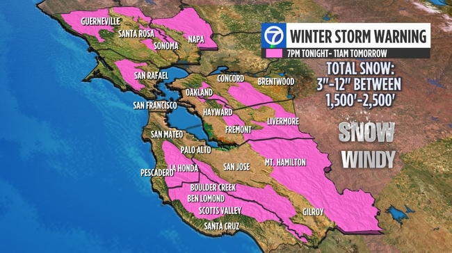
Snow: A Winter Storm Warning will go into effect this evening for our hills and peaks. Likely the heaviest snow will fall between 10 p.m. Thurs - 6 a.m. Friday

Tuma says it is now within the realm of possibilities that parts of the East Bay Hills, like Grizzly Peak, could see 6"-12" of snow by Friday. It's even possible Twin Peaks in San Francisco could see flurries or a dusting of snow Friday morning.