San Lorenzo River causes flooding in Santa Cruz mountains following major storm
One of the towns hardest hit by the storm was Felton - a town underwater.


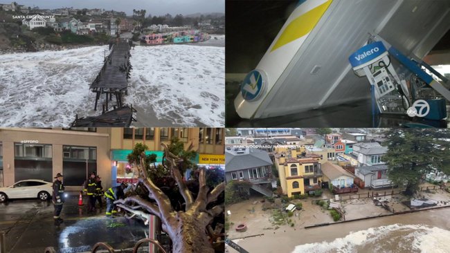
FELTON, Calif. (KGO) -- Evacuation orders are in effect for multiple communities in Monterey and Santa Cruz counties Monday morning due to the stormy weather that continues to hit the region.
One of the towns hardest hit was Felton - a town underwater.
"This was bad," Felton resident Cindy Pressley said. "I knew it was going to be bad because everything is so saturated."
Drone video captured homes completely surrounded by flood waters from the San Lorenzo River.
RELATED: Bay Area storm live updates: Evacuations, flooding and road closures being reported across region
The river hit its crest of 24.52 feet around 7:45 this morning, the second highest mark in modern history dating back to 1937.
Water began to recede after that, but residents in the area who did not evacuate had no place to go.
"We had the trifecta with the mudslides, and the trees down and the flooding," Pressley said. "So we are kind of trapped up here in our one way out Canyon."
Cindy Pressley lives in the Lompico Canyon area of Felton.
LIVE: Track rain in San Francisco Bay Area with Live Doppler 7
Neighbors sent us some of those images of flooding, slides and other major storm damage.
Elsewhere in Felton, some of the iconic town sights, like the landmark covered bridge, were completely flooded.
A notorious flood in 1982 was the worst ever for this area, the river hit 28.8 feet then.
RELATED: TAKE ACTION: Get help during extreme weather emergencies
Pressley says this storm has many similarities and she's concerned she will be stuck here for awhile.
"It's one way out, so we're here for the long-haul," Pressley said. "It might be days. In the past it has been days because we're kind of out here in Lompico, so they don't often get to us."
Not many people will be getting in and out of the area anytime soon due to other closures throughout the area.
We tried several paths to get down to Felton today. But many roads, like Highway 17 at Glenwood Drive, were shut down due to slides.
Bryan Zailer was supposed to go to over the hill for work, but he says it's just not safe do so today, especially on the smaller roads.
"They'll have trees that go over them, they'll have mudslides," Zailer said. "When I went through Mt. Charlie 6 years ago, I had a tree on one side of me and I was looking straight down the cliff on one side because it had washed out. You'll get up there and get pinned if it gets shut down you know?"
"So, nowhere you want to be when it's raining like this?" ABC7 News Reporter Dustin Dorsey asked.
"Oh, no. No," Zailer said.
Caltrans says it's unclear when Highway 17 Southbound may reopen. But workers we spoke with at the closure on 17 said it might be tomorrow.
VIDEO: Video shows extent of damage left behind around Bay Area by deadly Level 5 storm
Monterey County residents are encouraged to check if they are in an area under evacuation order by typing in their address into the county's website, while Santa Cruz County residents can do the same via the Zonehaven platform.
Evacuations are in effect in and around Watsonville near the Pajaro River, which is under a flash flood warning by the National Weather Service. In Monterey County, the zones being evacuated in that area are B-001A, B-003, B-005, B-007A, B-006, B-0012A and B-0012B.
In Santa Cruz County, the zones in the area under evacuation are WTS-E019, WTS-E017, WTS-E018, PAJ-E029, PAJ-E027, PAJ-E026, WTS-E006, WTS-E005, PAJ-E024 and PAJ-E015.
Other parts of Monterey County under evacuation orders Monday morning are low-lying areas of the Carmel River, low-lying areas of Big Sur River and low-lying areas of Arroyo Seco River.
In Santa Cruz County, other neighborhoods being evacuated include Felton Grove, Ben Lomond and Rio Del Mar.
Temporary evacuation points in Monterey County are open from 8 a.m. to 5 p.m. at Carmel Valley Library at at 65 W Carmel Valley Road, Prunedale Library at 17822 Moro Road and King City Library at 402 Broadway St., while emergency shelters are at Prunedale Grange Hall, 17890 Moro Road, Sherwood Hall, 940 N. Main St., Salinas, Monterey Room at the county fairgrounds, 2004 Fairground Road, and King City Recreation Center, 401 Division St., King City.
In Santa Cruz County, an overnight shelter has opened at the county fairgrounds at 2601 E. Lake Ave. in Watsonville, Cabrillo College at 6500 Soquel Drive in Aptos, Scotts Valley Community Center at 360 Kings Village Road, Resurrection Church at 7600 Soquel Drive in Aptos, and 7th Day Adventist at 1931 Soquel San Jose Road in Soquel.
Storm updates from Monterey County can be found here.
Bay City News contributed to this report