Bay Area storm live updates: Salinas River in Monterey Co. downgrades evacuation order to a warning


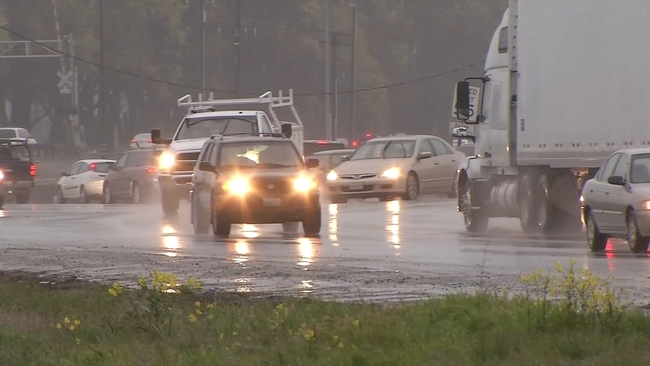
SAN FRANCISCO (KGO) -- Scattered showers are with us today with a Level 1 system on ABC7 Exclusive Storm Impact Scale. both today and Sunday.
Rainfall through the weekend will range from .10"-.75".
A Flood Watch has been canceled for the Bay Area but remains for the Delta and Carquinez Strait through Sunday morning.
Southerly winds and rain will be more widespread Sunday Afternoon. Heavier downpours will be possible in the overnight hours as well.
A level 2 system is still expected late Monday night as another atmospheric river arrives through Tuesday.
Power Outages
Here are the number of customers impacted, as of 11 a.m. Friday:
- East Bay:162
- North Bay: 805
- Peninsula:1,148
- South Bay: 783
- San Francisco:23
Road Closures
Here are the roadways impacted by the storm as of 11 a.m. Saturday:
East Bay Region:
No reported closures due to storm this morning.
North Bay Region:
No reported closures due to storm this morning.
South Bay Region:
- SR 152 closed at Watsonville Rd. to Santa Cruz County Line
- U.S. 101 from SR-152 to SR-25 One Lane closed due to flooding.
Peninsula Region:
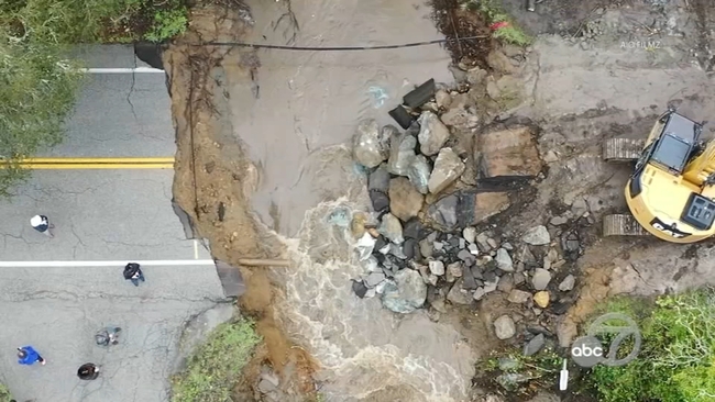
- SR-84 at Portola Road closed due to sinkhole.
NB US-101 off-ramp to 3rd Ave closed due to flooding.
Saturday
8:30 p.m.
Salinas River in Monterey County downgrades evacuation order to a warning
Monterey County emergency response officials have just downgraded an evacuation order for the Salinas River to an evacuation warning, according to a county spokesperson.
This evacuation order was announced by the county as of 8 p.m. Saturday.
The downgrade came at 8:30 p.m. Saturday.
6:30 p.m.
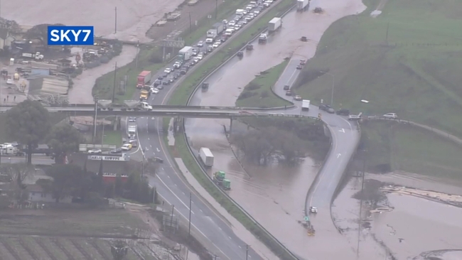
Pajaro River levee breach now 120 feet wide
The levee breach along the Pajaro River, upstream from the Monterey County community of Pajaro, is now 120 feet wide as of early Saturday evening, according to county officials.
The breach occurred just before midnight late Friday evening.
The water is flowing freely through the breach, according to Maia Carroll, a spokesperson for Monterey County. She added that state and local engineers are assessing the situation and determining next steps.
Overnight Friday to Saturday, emergency personnel conducted more than 90 rescues in the area, Carroll said. Door-to-door evacuation notifications began at approximately 3 pm. Friday to connect with residents who may not have left when emergency notices were issued.
As of Saturday evening, residents who have not leave the area are still encouraged to do so. MST buses are providing free transportation to shelters, and temporary evacuation points. Pick up location is at the Pajaro Golf Course.
Carroll said high-water vehicles, dive and search and rescue and mutual support agencies are working in the area. No deaths or injuries have been reported.
1 p.m.
Evacuation Warnings lifted for Big Sur, Carmel Valley, Bolsa Knolls, officials say
Evacuation warnings have been lifted for all areas of Big Sur River, Carmel Valley and Bolsa Knolls in Monterey County, the Monterey County Office of Emergency Services said Saturday afternoon.
The warnings have been lifted effective immediately, according to the emergency services office.
The Monterey County Sheriff's Office shortly before noon Saturday issued an evacuation warning for areas of the Salinas River to go into effect immediately until further notice.
Zones E-0016 and E-0021 are under evacuation warning.
Sheriff's officials said those with who have large animals or need extra time to evacuate should do so immediately.
An evacuation warning means those in a specific area should be prepared to evacuate at any time. When such a warning is issued, those in affected zones do not need to leave their homes at that time but should be alert and prepared to leave if an evacuation order is called.
10:15 a.m.
State Route 84 closed in both directions in San Mateo Co. due to sinkhole: Caltrans
Highway 84 is closed in both directions at Portola Road to Skyline Boulevard says Caltrans and San Mateo County Sheriff. Officials said a landslide caused major damage to the roadway and that there is no estimated time for reopening.
10 a.m.
Flash Flood Warning issued for Pajaro River, town in Monterey Co., NWS says
The National Weather Service has issued a flash flood warning for the Pajaro River and the town of Pajaro in Monterey County effective immediately until 11:45 a.m. Saturday.
Major life-threatening flooding is forecast, county officials said Saturday morning.
The flash flood warning affects the Pajaro River levee breach area and Township of Pajaro to the Pacific Ocean, according to the Monterey County Office of Emergency Services.
9 a.m.
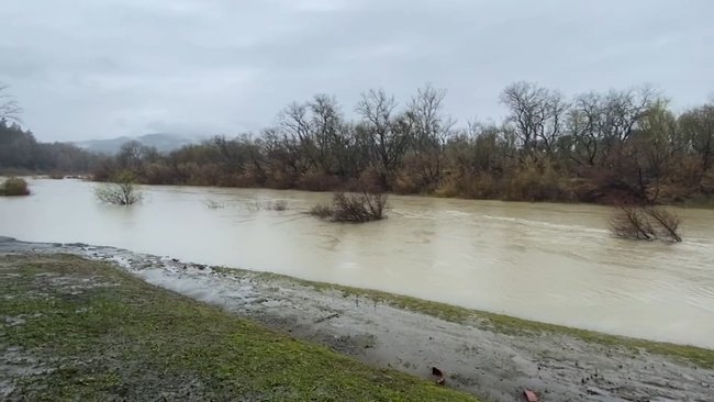
Flood Warning issued for Salinas River in Monterey Co., NWS says
A flood warning is continuing to be in effect for the Salinas River near Bradley affecting Monterey County, the National Weather Service said Saturday morning.
Minor flooding is forecast for the Salinas River, according to the weather service.
The weather service cautioned motorists not to drive around barricades or drive cars through flooded areas.
Drivers should be especially cautious at night when it is harder to recognize the dangers of flooding, the weather service said.
Additional information is available here.
8 a.m.
Pajaro levee breaks in Monterey Co., prompting evacuations
The Pajaro River levee was breached overnight on Friday night, prompting evacuations.
The levee was breached at about midnight, according to a news release from the Monterey County Health Department.
Teams from the county's water resources agency and state department of water resources were onsite at the time attempting flood-fighting efforts.
Evacuations of most of the Pajaro community were ordered just before midnight and expanded shortly after to include all flood zones in the Pajaro area.
National Guard high-water rescue vehicles were stationed in the area to help the evacuation effort, which included door-to-door checks from Monterey County sheriff's deputies, Cal Fire crews and North Monterey County firefighters.
Repairs to the levee are expected to take place on Saturday during daylight hours.
There are emergency evacuation shelters at the Santa Cruz County Fairgrounds, located at 2601 East Lake Ave., in Watsonville, in the Crosetti Building, and at the Compass Church, located at 10325 S. Main Street, in Salinas.
Residents can get a ride to a shelter at a temporary evacuation point, which are located at the Prunedale Library, at 17822 Moro Rd., the Carmel Valley Library, at 65 W. Carmel Valley Rd., and the King City Library, at 402 Broadway St.
For assistance with animals, the SPCA can be reached at 831-373-2631, and after normal hours at 831-646-5534.
Friday
6 p.m.
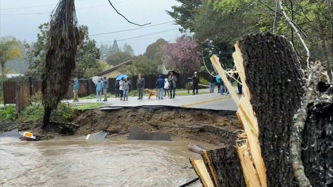
Road collapse in Santa Cruz County closes in 450+ homes
As expected, the atmospheric river hammered Santa Cruz County, and now hundreds of homes in the community of Soquel are cut off after a road collapsed.
Soquel's Main Street at Bates Creek caved in, closing in more than 450 homes.
"I've lived here my whole life and I've never seen the creek go actually through the road," said Nick Maleta who lives near the collapse.
The cause of the collapse was a six feet culvert underneath the road that got washed out in the rain.
"I just can't go to work and can't do everyday normal errands and activities," said resident Gabby David, "We're all pretty stuck here."
Residents like David were finally able to get foot access to the other side of the collapse thanks to neighbors like Mina Feuerhaken, whose property leads to a small private foot bridge.
With hundreds walking through her yard all day, Feuerhaken admits that the foot traffic outside her home was strange. Still, she says it's the least her family can do.
"If there's a health emergency back here, I mean, there are 2,000 probably, that live up here," she said, "So we're more than happy to be providing that support line."
Santa Cruz County spokesperson Jason Hoppin thanking the property owners for providing that access which has also been helpful to crews as they work to make repairs.
The road is just one on the county's long list of repairs to be made after devastating weather since Jan. and beyond.
"We're still recovering from 2017," Hoppin said, "We've got roads that haven't been fixed from that storm so these things are kind of layering on top of each other."
Main Street continues to be an immediate focus for the county. Residents holding onto hope that they'll be able to have access back soon.
"(We're hoping) to get to our normal life as soon as possible," Feuerhaken said, "Within 48 hours would be great."
The county says they expected to be able to get temporary vehicle access to those residents by Saturday adding that they are hopeful that President Biden's disaster declaration for the State of California will bring them some added resources to be able to fix problems brought on by these back-to-back storms.
4 p.m.
Storm brings flooding, toppled trees in North Bay
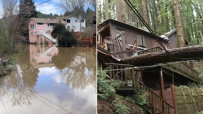
In the North Bay, people are cleaning up and drying out after the storm and there is still a lot of damage to assess.
Some neighborhoods in Guerneville were underwater, folks living on Mill Street woke up on Friday morning to nearly a foot of floodwater.
"It's crazy, it just came out of nowhere and I don't even know where it came from," said Jason Duenas.
Firefighters say the flooding came from swollen Mill Creek. The creek runoff flooded nearby Armstrong Woods Rd. overnight, leaving some drivers stranded.
The driver of a FedEx truck stalled out on Slusser Rd. and had to be rescued from the floodwater. Firefighters say the road was closed and signs were posted.
In Marin County, homeowner Josh showed us some startling damage, after a giant redwood tree toppled and split his Mill Valley home in half. Luckily, he and his family weren't home at the time.
"The storm took down a tree that was dead. We had already identified the tree would need to come down at some point but the tree took itself down a little early," he said.
1:45 p.m.
Sonoma Co. under Flood Advisory through the evening, NWS says
National Weather Service issued a Flood Advisory to cities in Sonoma County on Friday. The advisory is in effect until 7 p.m.
Residents can anticipate minor flooding or overflowing in low-lying and poor drainage areas.
12:45 p.m.
Valley Water issues flood declaration in Santa Clara County
Valley Water CEO Rick Callender issued a flood emergency declaration on Friday allowing the agency to take immediate action necessary to protect against or mitigate flooding, including but not limited to procuring necessary equipment, services, and supplies.
The agency's goal of this flooding declaration would protect against property damage and threat to life and public safety associated with flooding and high winds in the county and jurisdiction.
Valley Water said it activated its Emergency Operations Center (EOC) to monitor the storm and the impacts to our reservoirs and waterways as gusty winds and heavy rain might continue impacting the region into the weekend.


12:00 p.m.
Massive culvert in Soquel collapses in Santa Cruz County amid major storm
The atmospheric river has been hammering the Santa Cruz Mountains throughout Thursday night and well into Friday morning.
ABC7's Lena Howland said It caused some evacuations in the town of Felton but it also forced a massive culvert in the small town of Soquel to collapse.
As heavy rain pummeled Santa Cruz County and Bates Creek in Soquel reached flood stage, a large culvert collapsed in the middle of the night under Main Street and the road caved in.
"I've lived here my whole life and I've never seen the creek go actually through the road, it was just nuts, like really crazy," Nick Maleta, a neighbor said.
Santa Cruz County officials said people living north of Bates Creek aren't able to pass until road crews come up with a safe solution.
"One way in, one way out," Charley Hodson, a neighbor said. "There's no way, there's no, it doesn't hook up with old San Jose Road, it doesn't hook up with anything."
Hodson woke up to this chaos in the middle of the night and he believes hundreds of his neighbors on the other side of this culvert are now cut off.
"All those people as I understand it, are cut off from gas and electric and water, all that kind of thing," he said.
Meanwhile, just a few houses down from this, Nick Maleta, who lives in a tiny home in the backyard of his family's property, was kept up all night.
"It's like a tornado," Maleta said. "All night long, you could hear, the water is so saturated right and the cottonwoods especially are so weak, you could just hear them tumbling all night long."
He says, his family hasn't seen creek levels rise like this in more than 20 years, up until this year.
"And it happened four times this season," he said.
Meanwhile, as construction crews, PG&E and local first responders work come up with a plan for the collapsed culvert, all eyes and all hearts are on those stuck on the other side.
"We just hope that everyone's safe, that's the thing," Hodson said.
Crews will likely be on scene for the rest of the day, if not for the next week, working to make repairs and get this road fixed to let people pass as soon as possible.
11:45 a.m.
All lanes on I-580 in Oakland reopen after flooding closure
All lanes on Interstate 580 in Oakland have reopened after shutting down Friday morning due to flooding, Caltrans said.
11:00 a.m.
President Biden approves emergency declaration
President Biden has approved an emergency declaration for the entire state of California.
Governor Newsom had previously declared a state of emergency for much of California -- including more than half the Bay Area's counties.
The emergency declaration enables impacted counties to immediately access Direct Federal Assistance to help protect public safety and property. The request for Direct Federal Assistance includes generators, road clearance equipment and potential sheltering and mass care assistance.
10:50 a.m.
Southbound Highway 101 south of Gilroy closed due to flooding, CHP says
The California Highway Patrol said southbound US-101 south of Gilroy is closed due to flooding from 10th St. to State Route 25. The CHP said the estimated time of reopening is unknown due to the additional wet weather forecasted.
9:30 a.m.
Niles Canyon Road closed due to flooding
Niles Canyon Rd. between Pleasanton and Fremont remains closed from flooding. The CHP says alternate routes are I-680 to N. Mission Blvd. or I-580 to 238.
9:25 a.m.
NWS cancels Wind Advisory for Bay Area
The National Weather Service says the Wind Advisory for the Bay Area has been canceled. Winds peaked overnight and continue to subside. Could still see gusts 20-30 mph through this afternoon.
9: 15 a.m.
CHP gives several updates on what roadways are open, closed in San Mateo County
Highway 92 is open with exception of normal construction.
Highway 84 west of Portola road is mudslide with half of lane open.
San Francisquito Creek is receding.
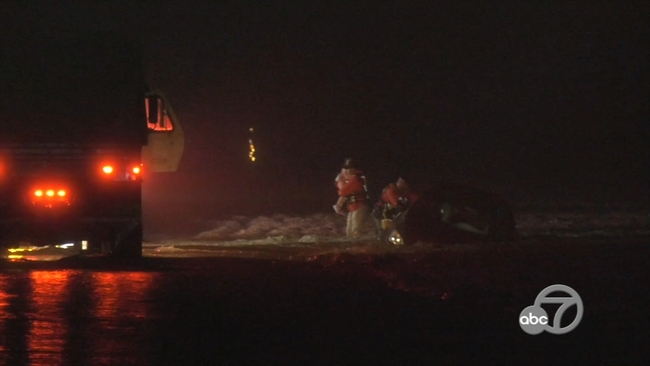
Pescadero Creek / Bean Hallow car into water. Locals rescued driver and fire cleared
8:30 a.m.
1 killed, 1 injured in partial roof collapse at Oakland warehouse, Oakland fire department says
The Oakland Fire Department responded to a deadly partial roof collapse at a warehouse Friday morning during the storm.
Latest update here.
7:30 a.m.
Soquel in Santa Cruz County closed to flooding
Officials say the main street in Soquel is washed out at Bates Creek in Santa Cruz County. A shelter-in-place alert has been issued for residents of Cherryvale, Glen Haven, Prescott and other neighborhoods north of Bates Creek. The county says it is working on a solution.
For South County residents subject to evacuation orders, due to flooding at the College/Lake/Holohan intersection, officials say please use alternative routes to access shelter at the Santa Cruz County Fairgrounds.
Carlton or Casserly roads to E. Lake are both open.
7:15 a.m.
State route 129 closed due slides, officials say
Officials say the roadway on SR-129 between Murphy Crossing to US 101 is closed due to slides. They are reminding drivers to not drive through slides.
Officials also say SR-152 at Casserly Road is also closed due to slides. Please use alternate routes.
7 a.m.
2 Palo Alto street roadways closed due to flooding
Palo Alto police said two roadways are currently closed due to flooding:
West Bayshore Road between Loma Verde Avenue and Fabian Way, and the 1000 block of East Meadow Circle.
6:45 a.m.
Green Hills Road closed in Scotts Valley, police say
Police in Scotts Valley are reporting Green Hills Road is currently closed from Falcon Ridge Road to 1500 Green Hills Road due to a large mudslide.
Police and public works are on the scene working to clear the mudslide.
Police did not have an estimate of when the roadway will reopen.
The advisory about the road closure was sent out at around 5:34 a.m.
6:30 a.m.
Guerneville School District closed Friday
The Guerneville School District in Sonoma County announced that school will be closed on Friday due to creek flooding affecting the parking lot and nearby roads.
5 a.m.
Flooding closes I-580 in Oakland
Both directions of I-580 in Oakland near 35th Ave have been shut down due to flooding. Eastbound traffic is being diverted off at 35th Ave and westbound traffic is being diverted at MacArthur Blvd/High St. CHP tells drivers to use 880 as an alternate round, but to expect heavy commuting delays.
4:30 a.m.
Areas in Santa Cruz Co. remain under evacuation warning, schools close
Flooding in Santa Cruz County areas such as the Felton Grove community has been so intense that deputies were going door to door evacuating anyone that was still home around midnight.
Sean Gianni, a Felton Grove resident, said it was his fourth time being evacuated and he was told by deputies to leave around midnight or else he would be at risk. Despite many homes being raised up along the San Lorenzo River, he worries about the ones stuck at ground level.
"The river comes like super far up, there are a couple of houses in the neighborhood that aren't even raised so they are going to go completely underwater."
Several cities in Santa Cruz County are under evacuation warning and officials are providing shelter locations for residents to go.
The areas being evacuated are Felton Grove, Paradise Park, Soquel Village, Rio Del Mar Flats and areas along Corralitos Creek.
These are the shelter locations:
- Watsonville Vets Hall, Pets in carriers only, No RV parking
- Cabrillo College Gym, Pets in carriers only, RV parking (no hookups)
- Ramsay Park (TEP), No pets, No RV parking
- Crosetti Hall Santa Cruz County Fairgrounds, Pets in carriers only, large animal evac., RV parking (no hookups)
- Depot Park (Overnight warming center only, until 8 a.m.), No pets, No RV parking
- Scotts Valley Community Center (TEP), No pets, No RV parking
The following schools will be closed in Santa Cruz County within the Pajaro Valley Joint Unified School District:
- Ann Soldo Elementary School
- Pajaro Middle School
- Watsonville High School
- Renaissance High School
- Watsonville Infant Centerl
4 a.m.
Tree falls on San Anslemo home

A large tree came crashing onto a home on Hillside Avenue in San Anselmo Thursday night.
There appears to be some damage to the roof, but it isn't clear if anyone was home when the tree fell.
Thursday
10:30 p.m.
Flooding on Hwy. 12 in Santa Rosa
Highway 12 near Stony Point Road and several other streets in Santa Rosa are closed due to flooding, Santa Rosa fire tweeted.
10:15 p.m.
Cars stuck in floodwaters in North Bay; saturated soil a concern

In the North Bay, cars stuck on flooded roads kept many first responders busy Thursday night.
"We were initially concerned with the rainfall intensities that were projected as well as the winds. For us, with how saturated our soils are, we are a lot more concerned, at least here locally, with what damage could potentially be done," says Division Chief Paul Lowenthal, with the Santa Rosa Fire Department.
He says Thursday didn't have many downed trees or power lines. Most of the evening was just steady rain and a number of flooded streets. But he adds, the potential for bigger issues is always a big concern.
"We are still at risk with our Glass Fire. The Glass Fire burn scar from 2020 has not regrown like it should have. So, the water tends to come off that hill a lot more rapidly than it does most of our hillsides," explains Lowenthal.
That water then quickly fills up the Santa Rosa Creek, which in turn can back up the tributary creeks.
"And that's what's keeping out street crews very busy tonight. Dealing with a lot of backup, a lot of storm drains that can't flow, and resulting in a lot of flooded out road ways," says Chief Lowenthal.
In Forestville, two cars got stuck and required passengers to be rescued. No one was injured. But it's another example of problems due to flooding.
Trevor McCal delivers auto parts. There is no brake in his schedule. He had to deal with the heavy rain on the freeway. And he'll be back out again on Friday.
"We have some of our routes that have been canceled because of snow and down trees. But I have to go to the East Bay, Oakland, San Leandro, and it's crappy out there. But nothing you can do," says McCal.
"(It's been) horrible. I could barely see on the freeway. I just drove back from Petaluma. And it's outrageous," says Shelby Wilcox, as she described the evening commute.
She was also stuck in traffic and the rain during her commute from Petaluma to Santa Rosa. She does deliveries, so she will be out most of the overnight.
"Rain or shine, I will be stuck in the weather. Hopefully, it doesn't get any worse," says Wilcox.
Chief Lowenthal wants to remind residents to survey their property on Friday when the rain stops. He says it is important to clear out storm drains to keep things moving, and make things are in good shape ahead of the next storm.
10 p.m.
South Bay braces for intense rain, strong wind
As the rain and winds pick up around the region, so too are efforts to keep floodwaters from causing the same widespread damage suffered in Jan.
Back then, SKY7 gave us an overhead view of the major flooding along Highway 101 in Gilroy. Many witnessed a home and family-owned farm submerged in that storm. On Thursday, entire structures can be seen from a distance.
VIDEO: Homes, highway in Gilroy hit by major flooding
Although The Garlic Shoppe, located just across the freeway from the properties, was untouched by floodwater then, co-owner Alex Larson said they aren't taking any chances.
"Probably going to have everybody come over tonight and we'll lift everything up off the ground again, to make sure that we're four feet off the ground. So that we don't have any product that's going to get ruined if anything does happen."
Valley Water officials warned south county is likely to see some significant rain overnight Thursday and into early morning hours on Friday.
Matt Keller with Valley Water said, "We're keeping an eye on the possibility that maybe Highway 101 could flood just like we saw in January. We're hopeful that it won't, but it's better to be prepared."
County officials are urging people to be mindful of their surroundings, obey flooding signs, and follow the direction of safety professionals as many of us have had front row seats to the power of recent storms.
9:40 p.m.
Newsom requests Presidential Emergency Declaration to support storm response
Gov. Gavin Newsom requested a Presidential Emergency Declaration Thursday to authorize federal assistance to support state and local resources as an atmospheric river pummels the state.
"California is deploying every tool we have to protect communities from the relentless and deadly storms battering our state," said Governor Newsom. "In these dangerous and challenging conditions, it is crucial that Californians remain vigilant and follow all guidance from local emergency responders."
If the declaration is approved it will enable impacted counties to immediately access Direct Federal Assistance to help protect public safety and property. The request for Direct Federal Assistance includes generators, road clearance equipment and potential sheltering and mass care assistance.
Newsom announced a state of emergency in 21 counties Wednesday which included San Francisco, Santa Clara, Santa Cruz and Monterey.
7 p.m.
1 injured after tree falls on car in San Mateo County
One person was injured after a tree fell on the Tesla they were riding in Thursday night in San Mateo County, according to the California Highway Patrol.
CHP says officers responded to the scene just before 7 p.m. on Skyline Boulevard just south of Old La Honda Road.
Two people were traveling inside the Tesla when the tree fell on the vehicle. One of them suffered injuries to their leg and was taken to the hospital.
CHP says at this time Skyline Boulevard is shut down due to the large tree blocking all lanes.
6:15 p.m.
Large tree blocking 2 NB lanes on I-280 in San Bruno
A large tree is blocking two lanes of northbound I-280 in San Bruno just south of the Crystal Springs on-ramp. The CHP say emergency crews are en route to remove the tree and drivers are urged to proceed with caution.
5:55 p.m.
Reports of flooding, mudslide on Crow Canyon Road in Castro Valley
The California Highway Patrol tweeted Thursday night there are reports of flooding and a mudslide on Crow Canyon Road in Castro Valley. They are urging drivers to use caution.
5:40 p.m.
North Bay first responders brace for flooding, water rescues
In the North Bay, residents and first responders are bracing for the real possibility of flooding across the region from the storm.
Sonoma County firefighters are pulling water rescue craft out of storage in Forestville which will likely be needed as the storm river intensifies and levels on the Russian River rise.
"Our big message to people is if you don't have to be out don't be out, don't. Don't drive through standing water, you don't know how deep it is," said Sonoma County Fire Division Chief Cyndi Foreman.
Tragically, a woman lost her life in Sonoma County last January when she was trapped in her car by floodwater.
The fire district is up staffing crew for the storm, opening its district operations center to help monitor trouble spots, as they did two months ago during severe storms.
"We will see significant rain in the next 72 hours," Foreman added.
Residents were filling last-minute sandbags to protect homes and garages, but his real worry is about flooded roads.
4:45 p.m.
5 taken to hospital after multi-vehicle weather-related accident in Walnut Creek
At least five people were taken to the hospital after an accident involving a county bus in Walnut Creek on Thursday evening. Fire officials say the injuries range from critical to moderate and 10 patients were evaluated on the bus. They say the cause appears to be a vehicle exiting the freeway too fast "for the weather."
4 p.m.
SJ mayor joins 311 team to highlight importance of calling for storm cleanup to prevent flooding
To celebrate 311 Day this weekend and the valuable city resource, San Jose Mayor Matt Mahan popped on a headset in the 311 call center to answer some calls for non-emergency service in the city. He was then dispatched out into the field to help out crews on their various calls, including helping clean up gutters and storm drains with another storm setting in on the region.
"During the storm, as residents see trees and branches down, see storm drains backing up, or other things that don't look right during the storm, 311 is a great place to go," Mayor Mahan said.
The governor declared a state of emergency for Santa Clara County Thursday, while San Jose city leaders said their own state of emergency is ongoing to provide aid as needed. Valley Water crews have been hard at work clearing out creeks as flood risk still remains high, especially to San Jose's south. One of the best ways to do your part is reporting storm drain clean up on 311 to help the Department of Transportation prevent flooding.
"We've gone through and cleaned those out, many of them two or even three times at this point due to all the rain that we've had this season," SJ Dept. of Transportation PIO Colin Heyne said. "We've got crews monitoring calls from residents right now and in their free time, if they have any, they are clearing leaves and other debris."
Critical work during what is expected to be a serious storm.
2 p.m.
Napa County under Flood Watch from March 9-12
Napa County sent an alert that it is under a Flood Watch from Thursday afternoon through Sunday morning.
"This weather event is expected to bring winds, heavy rain, flooding, and increased potential for power outages. Due to very saturated soils, even winds on the lower end of the speed range can cause downed trees. When trees fall, this can be a threat to lives, cause power outages, and add debris to our roadways," officials said in the alert.
Residents are asked to please continue to exercise caution when on the road. If you see a downed or sagging power line, assume it is energized and extremely dangerous. Do not touch or try to move it, stay clear of the area, call 911 and PG&E at 1-800-743-5002.
1:30 p.m.
San Francisco extends hours for sandbag distribution
San Francisco Public Works said that it would be extending its hours of distribution for sandbags to 5 p.m. for residents due to the pending atmospheric river.
Residents and businesses can receive up to 10 free sandbags from the city, which can be picked up at the operations yard on Kansas and Marin streets.
More info can be found at sfpublicworks.org/sandbags.
1 p.m.
Areas of Santa Cruz County under evacuation warning
Due to likely flooding, the following areas of Santa Cruz County are under evacuation warning:
- Felton Grove
- Paradise Park
- Soquel Village
- Rio Del Mar Flats
- areas along Corralitos Creek, including the College-Lake-Holohan area
County officials say that "if you flooded in January, you are likely to flood again. Please be prepared to leave if necessary. This is a warning not an order, but leave now if you feel unsafe."
Residents can look up their zone at community.zonehaven.com.
11 a.m.
South Bay crews, residents prepare for flooding
All eyes are looking towards the sky Thursday morning, to see when the next atmospheric river will roll in.
"If it stalls over us and we get a lot more rain than expected or anticipated, we could see some local creeks and rivers impacted," Matt Keller, a spokesman for Valley Water said.
Valley Water crews spreading out across the region to keep these creeks like the Alma Creek flowing, making sure there are no blockages causing a back-up and gearing up in hopes to avoid a repeat of January's storm.
"If there's a possibility you've seen in the past that flooding is happening around your home, or there's some low lying areas where storm drains get backed up, go get those sandbags today," Keller said. "You don't want to be shoveling sand when the rain's coming down."
Lessons learned from the last major storm at the start of year, folks across San Jose weren't taking any chances this time around, picking up sandbags at five different locations across Santa Clara County.
"Storm drains just clog, especially in a more populated city, the more people, the more traffic, the more debris that we have to get into those storm drains," Colin Hayne, a spokesman for the City of San Jose's Department of Transportation said.
With 35,000 storm drains spread out across San Jose, some of which, still being cleaned out from the last storm, the city's Department of Transportation has crews spread out 24/7 working to help respond to calls of ponding near drains.
"So as soon as you see that ponding happening, in a storm inlet, give us a call, our crews are out there just cleaning these drains all day long, they're pretty quick, sometimes even the sidewalk gets flooded and we want those areas clear for people to travel safely," Hayne said.
And knowing history could repeat itself from January, their crews are also bracing for the possibility of even more downed trees.
"Winds are forecasted and with the saturation in the soil, that makes it more likely for trees, weaker root systems to blow over, so just be alert really, that's all we can say right now," he said.
If you have a large tree in your yard, it is wise to keep an eye on it in this incoming storm and if you have time before it starts coming down, the city says it may be time to get it pruned.
If you see a power line with a tree resting on it or power lines down in the street, do not approach and instead, call 911.
9:00 a.m.
Monterey County closing parks
Monterey County will close some of its parks ahead of a severe weather system set to arrive in the area Thursday and Friday.
Jacks Peak, Manzanita Park, Royal Oaks Park, San Lorenzo Park and Toro Park will be closed to protect the health and safety of visitors from the heavy rain and strong winds forecasted in the forthcoming storm, according to the county.
San Lorenzo Park RV Campground will remain open. Lakes San Antonio and Nacimiento will also remain open for camping and boating.
Wednesday
11:30 p.m.
Governor Newsom declares storm state of emergency supporting 21 additional counties
Governor Gavin Newsom announced a state of emergency Wednesday to help California counties ahead of a severe winter storm this week.
The latest proclamation will help with disaster response and relief for 21 counties, including San Francisco, Santa Clara, Santa Cruz and Monterey counties.
The state will be using all available resources to help residents impacted by the storm.
11:15 p.m.
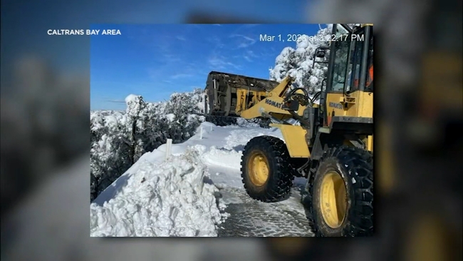
Road to Mt. Hamilton summit could reopen by Friday, Caltrans says
The snow covered summit of Mount Hamilton is home to about 30 resident staffers of the Lick Observatory. The peak was pummeled with a record amount of snow over several recent storms.
"Right now, we're still overwhelmed with snow. The official snow tally as of yesterday, since February 22, is 53 inches of snow on Mt. Hamilton," resident astronomer Dr. Elinor Gates said.
Thursday's incoming storm is creating additional concern, especially with strong winds and intense rain expected.
"We still have snow and ice in the way. So where's that water going to go? It's going to flood through our plowed drives and walkways. We might have ice dams, so it might end up going underneath shingles and leaking into houses."
She also points to the possibility of ice and snow sliding from the observatory's domes. It's movement that could be dangerous for anyone or anything below.
Still, resident astronomer Dr. Paul Lynam says there is some welcome news, including warmer temperatures and better timing.
"Not in the immediate aftermath of the 2020 SCU Complex Fire, which left a lot of burn scars," he described. "At least we've had a season or two for the ground to recover and some of the vegetation to regrow. That will hopefully minimize those slippages, those rock slides and mudslides potentially."
Currently, the road to the observatory has been closed to the public for weeks, with barricades manned by law enforcement. One passable lane has allowed emergency and maintenance vehicles, and resident staffers to venture up and down the mountain. Caltrans crews and others have been working around the clock to clear the roadway.
"The next two days the road could still be treacherous not necessarily through the snow but just by flooding, mudslides, rockslides and downed trees," Dr. Lynam said.
Dr. Gates added, "It wouldn't be surprising, in our remote location, to lose power for maybe many days again. But our generator, with the full diesel tank, we can go for about a week."
Caltrans officials said they're monitoring conditions. Ahead of the storm, they're working to clear ditches to prevent flooding, watching for downed trees, and looking out for slides.
"Since we've been looking and monitoring the weather forecasts, and with all the cleaning that we've been doing, we're looking forward to being open by Friday," Caltrans PIO for Santa Clara County Victor Gauthier said.
11 p.m.
Danville residents prepare for more potential flooding
One neighbor could be seen moving her vehicle to higher ground. Everyone with vivid memories of El Capitan Drive flowing with water a couple of months ago.
"There was so much water coming down the street. There was actually an SUV floating down the street," said Danville resident Dia Mundle.
The neighborhood was hit especially hard during that atmospheric river as we began 2023, now another one is on the way.
"I think everybody in the neighborhood feels probably like the worst is over but now it looks like it may start all over again," said John Hughes of Danville.

John Hughes just finished redoing his front yard that was destroyed by all the mud from that storm, and now here we go again.
"It was really kind of scary. We had to be evacuated," said Hughes.
His family evacuated out their back door but both their cars that had been parked in their driveway were eventually totaled.
"We've been here since '75 and nothing close to it," said Hughes.
As to how those in the neighborhood are preparing now. Sandbags can be seen at at least two different houses, streets are now clear, and homes are working.
5 p.m.
No chains required yet on I-80 and Highway 50 to Tahoe
There are no chain requirements in effect for either I-80 or Highway 50 heading to Tahoe as of Wednesday evening.
For the latest on road conditions, visit here.
4:45 p.m.
Valley Water prepares in hopes to avoid flooding with 1st atmospheric river since Jan.
With an atmospheric river heading towards the Bay Area again, Valley Water is gearing up in hopes to avoid a repeat of January's storm. The Southern part of Santa Clara County is expected to get the most rain. Places like Morgan Hill and Gilroy saw serious flooding at the start of the year as well, so Valley Water has crews spreading out across the region to keep waters flowing.
"We hope that it's not going to be as bad, but in January, that one wasn't forecasted to be bad and it kind of just stalled over us," Valley Water spokesperson Meghan Azralon said. "So, we're taking those same precautions just in case. There's always a possibility that mother nature changes her mind."
Valley Water is also hard at work filling up sandbag locations across the South Bay as well. 4,200 bags were dropped off and quickly loaded up in Morgan Hill. Areas south of the county are forecasted to get more than two inches of rain leaving creek and stream flooding risks high.
Familiar with the risks that heavy rainfall can create, it's a constant state of preparation for some residents. They say when you see rain in the forecast, you don't get ready, you stay ready.
2 p.m.
Danville issues storm safety advisory ahead of storm
Danville issued a storm safety advisory Wednesday afternoon, warning residents to be ready for wet weather that will likely start Thursday morning.
Town officials say the three main areas of concern are rain and increased winds generating flooding, downed trees, and loss of power. They ask residents to avoid unnecessary travel during the storms and, if they do drive, to avoid driving through flooded intersections.
They also ask residents to remove leaves or debris blocking storm drains to allow stormwater to flow through unobstructed into the stormwater system. Danville will offer a self-fill sandbag station for community use at 1000 Sherburne Hills Road. They ask residents to limit use to 20 sandbags per household.
To report clogged storm drains, downed trees, or flooding, call Danville maintenance services at (925) 314-3450, or after hours contact non-emergency dispatch at (925) 820-2144. Residents can also make reports online.
1:50 p.m.
Vallejo warming shelter opens Thursday
The city of Vallejo is opening a warming shelter beginning Thursday in anticipation of extreme weather headed to the region.
The warming shelter will be open from 8 p.m. to 7 a.m. Thursday, Friday and Saturday at 505 Santa Clara St. on the backside of City Hall.
A limited number of blankets and pillows will be available, but participants are encouraged to bring their own. One small bag of personal items is also permitted.
Those seeking transportation to the shelter can get a free bus ride on SolTrans public transit by simply mentioning to the bus driver that they are traveling to or from the Vallejo warming shelter, a spokesperson for the city said.
RELATED: Yosemite National Park braces for flooding ahead of atmospheric river storm
10:30 a.m.
Oakland urges residents to call 311 to report downed trees, flooding
Wind and lots of rain are expected in Oakland starting Thursday morning and city officials urge residents to prepare and even volunteer to prevent flooding.
Emergencies such as downed trees or limbs can be reported by calling 311 or (510) 615-5566. If it's challenging to get a hold of someone by calling 311, residents can call the Oakland Fire Department's non-emergency line at (510) 444-3322.
Other emergencies that can be reported to 311 include flooding, overflowing sewers and street signals that aren't working. Non-emergencies can be reported online.
City officials are asking residents to adopt a drain in their neighborhood to help prevent flooding. Public works crews are clearing storm inlets and many residents have adopted a drain, but many thousands of drains remain available for adoption. The city can give residents supplies such as rakes, brooms, dust pans, and bags.
Call (510) 238-7630 or go to the adopt-a-drain website to sign up.
Up to 10 free sandbags and up to 20 feet of plastic sheeting are available to each Oakland household while supplies last. Pick them up at the Municipal Service Center at 7101 Edgewater Drive Monday through Friday from 8 a.m. to 4 p.m. and Saturdays and Sundays from 8 a.m. to 4:30 p.m.
10 a.m.
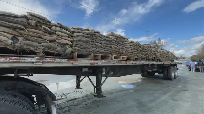
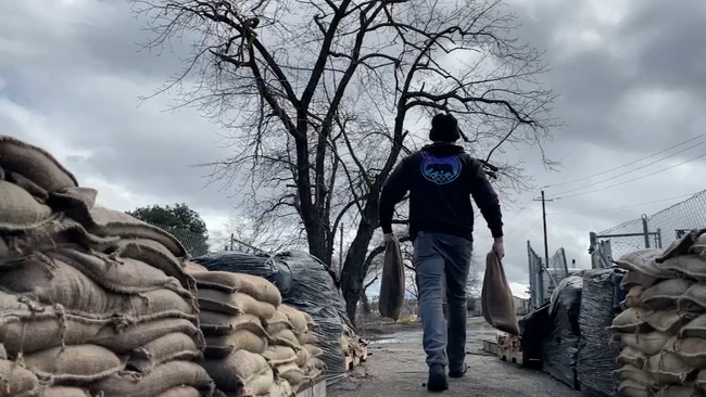
Monterey Co. distributing sandbags ahead of storm
Residents in unincorporated areas of Monterey County can pick up sandbags at several locations in the county ahead of another storm forecast to hit the Central Coast on Thursday and Friday.
Empty sandbags can be picked up at the following Cal Fire stations: Aromas, Big Sur, Cachagua, Cypress, Carmel Highlands and Greenfield, as well as stations in the North County Fire Protection District.
A complete list of sandbag locations can be found here. Bags can be filled at these locations.
For questions about sandbags, contact the Monterey County Public Works maintenance office at (831) 755-4925.
Residents in incorporated areas can pick up and fill bags at Fire Stations 11, 12 and 13 in the city of Monterey, the Vista Lobos community center in Carmel-by-the-Sea, and the Pacific Grove fire station.
RELATED: Is 2023 Bay Area's worst storm season? Here's what experts say
7 a.m.
Winter Storm Watch to effect Thursday for Sierra Nevada
A Winter Storm Watch will be in effect Thursday through Sunday for heavy snow and gusty winds. Snow levels will be high, above 6,500 feet (that is roughly the elevation of Soda Springs on I-80, Phillips on Highway 50) where two to five feet of snow will fall. Gusts up to 80 mph are expected.
3 a.m.
Flood Watch in effect from Thursday-Sunday for entire Bay Area
A Flood Watch is in effect from Thursday through Sunday for the entire Bay Area and the Central Coast. Lingering rain will continue into the weekend with additional widespread rainfall expected next week.
Click here to download the ABC7 News App to get your weather forecast on the go. And make sure you enable push alerts for immediate notifications and severe weather alerts. Click here for weather where you live.
Bay City News contributed to this report.