Live storm updates: Tree falls on I-280 in Peninsula during high winds


SAN FRANCISCO (KGO) -- The Bay Area is experiencing another rainy stretch with the possibility of heavy snow hitting the Tahoe area and faces a tornado threat in Northern California. Here are the latest updates.
TIMELINE: Flood Watch remains in effect for entire Bay Area with downpours Tuesday
WATCH: Latest AccuWeather forecast
LIVE: Track rain in San Francisco Bay Area with Live Doppler 7
POWER OUTAGES
The Bay Area is experiencing power outages as the storm progresses. Here are the numbers by county as of 3 p.m.:
San Francisco: 3
Peninsula: 388
North Bay: 1,211
East Bay: 754
South Bay: 939
Bay Area total: 3,295
MONDAY
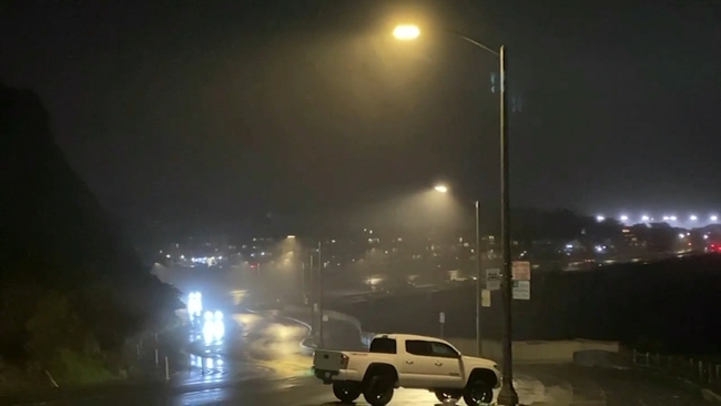
11 p.m. Tree falls on I-280 in Peninsula Monday night during high winds
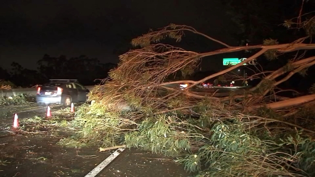
Traffic was at a standstill Monday night along I-280 Southbound in Burlingame after a massive tree came crashing down. The tree initially blocked all lanes of traffic. No one was hurt but it fell on a day where strong wind gusts and hard downpours were a problem along the Peninsula.
"It just happened so fast like water coming from everywhere and it was like raining, just water coming from everywhere," said Vanessa Contreras describing the rain and flooding her family witnessed Monday.
Contreras and her children had to walk through those conditions just to get from their car to their door in San Mateo. Her 9-year-old daughter Alejandra had this to say about it.
"I got soaked! My little brother actually slipped and I was trying to pick him up because he is a little bit heavy so it was kind of harder and it was raining really hard," said Alejandra.
"We got drenched, we got drenched within maybe 30 seconds. Not even 30 seconds, the 15 seconds it took for us to get from the car to the front door we were soaked," said Vanessa Contreras.
The wind though causing widespread issues. Appearing to knock power out to around one-thousand customers near Joinville Park in San Mateo.
"It was very very windy you could see the trees swing. There was actually sparkles and smoke coming in the middle of the road and then you could see the powerlines were down," said Ksenia Kouchnirenko whose home was without power when we spoke with her.
Five minutes down the road, the same story.
"I saw the wire, my next door neighbor's wire spark you know two or three times in a matter of 15 seconds or so," said Peter Quigley.
Fortunately PG&E got that situation under control. They're now working into the night to get power outages back online, just as Caltrans is working to clear roadways.
10 p.m. South Bay mall, businesses deal with intermittent power outages

The owner of Sweet Retreat ice cream shop in San Jose said the power came on and off at least three times on Monday.
Anjan Parikh, the owner, told his employees to avoid opening the freezer and take cash-only transactions when the power was shut off.
"Power is very important for us. Very important - it's our heartbeat," Parikh said.
Parikh said his biggest worry wasn't about losing customers on a busy holiday weekend, it was whether he was going to have to throw out 300 gallons of ice cream in the store.
"So any time a storm comes on, I always worry about the power. That's my number one priority," Parikh said.
After the third short outage, Parikh said PG&E alerted him power was restored which was a huge relief.
"I feel so good," Parikh said.
Across the street inside the Oakridge Mall, power was out in some stores and on for others.
San Jose resident Kora Dey said she was in Claire's when the lights turned off.
"A lot of the shops were closed. You were walking and then like one part of the mall was just completely out," Dey said.
Patricia Flores said her family killed time in a food court while power was restored at the Build-A-Bear Workshop.
"I guess all the people just went where all the lights were and then when they came on they started going on the other side. We were just happy that some of it you know was open," Flores said.
By Monday evening, power was restored at the Oakridge Mall.
7:45 p.m.:
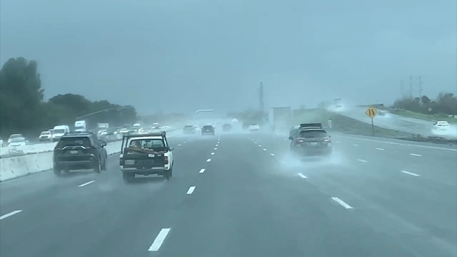
North Bay hit hard by heavy rain, gusty winds

In the North Bay, Monday's storm brought bought of heavy rain and gusty winds to the region, knocking down trees and flooding roadways.
A Santa Rosa man felt a big jolt and said it felt like an earthquake. But, it ended up being a big tree slamming into his home.
"It shook the whole house," said Davis Matthew.
Matthew is still a bit rattled by what happened this morning in Santa Rosa at his apartment off Fourth Street and Diamond Court.
Across Sonoma County, heavy downpours and powerful winds packed a punch.
At the Sonoma County Fire District Bodega Bay Station, flags were whipping in the wind.
In Windsor, Mark West Station Road was underwater.
Sonoma County Fire District said it has received many calls for fallen trees, flooded roadways and downed power lines.
Fortunately, no one has been hurt.
5 p.m. East Bay residents on high alert for rare tornado risk
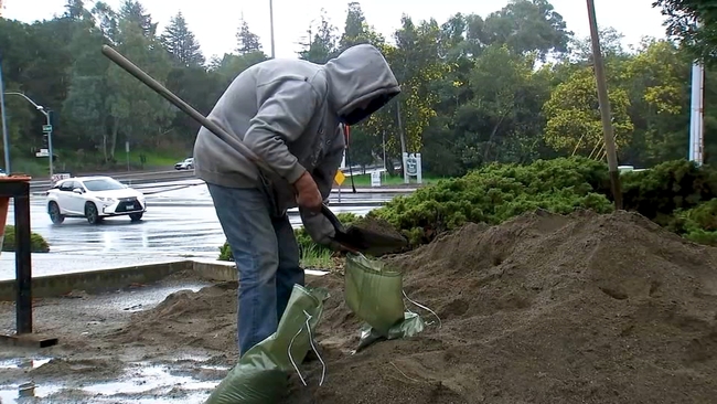
In Hayward, the weekend storms led many like Rob Hart to go out this morning to get sandbags.
"All the rain came down, debris clogged my drain. I came last night and it started flooding my garage," said Rob Hart, Hayward resident.
Multiple fire stations in Alameda County running low on sand as an influx of residents prepare.
"It got hit pretty hard yesterday. We are probably going to order some more sand later. We did have our fire crew pre-fill sandbags and we have a few left but they are going quick," said Battalion Chief Kent Carlin with Alameda County Fire.
With high winds, parts of the East Bay are also under increased tornado risk.
"Tornado in Hayward? Never. Hopefully I don't see one anytime soon," said Traci Washington, Hayward resident.
Battalion Chief Carlin urging the public to stay alert.
"With the high winds that we are experiencing now, we have a lot of weakened trees so if anybody hears any cracking or sees any leaning they should take note of that and take the proper notifications," said Battalion Chief Carlin.
4:30 p.m.
Interstate 80 corridor through Vacaville braces for severe storms
It's was a day of wild weather swings in Vacaville.
"We have been informed there may be some really extreme weather like thunderstorms, maybe some hail and even the slight chance of a tornado," said Captain Robert Jacoby with the Vacaville fire protection district.
"The thing we worry about most with any heavy rain is flooded-out streets so anyone on the road should be very careful."
Officials are also keeping an eye on the hillsides to the north for possible mudslides.
The weather swung to extremes throughout the day-raining substantially one minute-then 15 minutes later pockets of blue sky and sunshine.
And Vacaville residents also swung to extremes in their reactions to the weather
"I'm terrified. I have to work until 3 o'clock, and I've been praying all morning like my friend just gave me a hug, and I am hoping it skips over us," said Melanie Ashe, a Vacaville resident.
Renetta Trujillo, another Vacaville resident, described the day as just another storm. She said, "This is typical for this time of year and I'm thankful for the rain as we all are. I have friends from out of state texting me, and wishing me to be safe and be careful in this weather because they heard that tornadoes are coming and flooding and all that."
No one was taking any chances out at Nut Tree Airport at a flight school.
"My personal concern is that the aircraft are tied down well enough because if they get loose, it's all bad. If the weather continues like it has been all morning, there won't be any flying for us because as a flight school, we put a limit of 30 mph gusts," Denise Duncan with Wings Flight School said.
4 p.m.:
Severe Thunderstorm Warning issued for parts of Peninsula
The National Weather Service has issued a Severe Thunderstorm Warning for parts of the Peninsula which include San Mateo, Redwood City and Foster City. Forecasters warn this storm cell could produce a possible tornado.
11 a.m.:
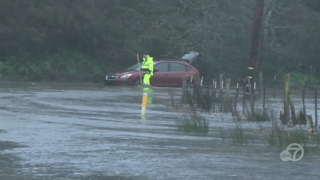
Full closure of Niles Canyon Road expected after 'slipout' of highway into Alameda Creek
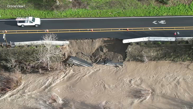
One way traffic controls are in place for part of Highway 84, known as Niles Canyon Road, just east of Palomares Road because of what Caltrans officials are calling "slipout."
An aerial view shows a portion of the highway cracked and slipping into the Alameda Creek on Monday morning, throwing a major wrench into some Presidents Day plans.
Caltrans says the slipout happened around 5 a.m. on Monday.
"When the roadway gets eroded, the ground underneath of it kind of washes out, then the pavement slips down right, or becomes unnavigable so we can't have people driving on it so that's what's going on out there right now and we're going to need to make a repair before we can open it all the way back up," Bart Ney, a Caltrans spokesperson said.
Caltrans crews are now out doing one-way traffic controls in the area from Pleasanton Road on Highway 84 to Washington Boulevard.
They're doing this now because Caltrans says it's just not safe to drive on the lane closest to the Alameda Creek which took on some major damage during Sunday night's storm.
Drivers stuck in traffic said they were surprised to see the damage after getting so little rain Sunday night.
But Caltrans says they don't have an ETA of clearing the slide just yet.
"We've had our maintenance engineers take a look at it so it's safe to traverse in one direction but what we'll have to do as soon as we get them out there, is to have construction engineers take a look at what needs to be done in order to repair the road then when we know what that is, then we can go ahead and take the steps to get the materials and the crews in to rebuild it," Ney said.
CHP confirmed they will be doing a complete closure of both lanes of this highway Monday night at 5 p.m.
They say Caltrans will return in the morning to reassess the situation but a long term plan for repairs is still to be determined.
Caltrans says locals can use Palomares Road to get around this.
8:30 a.m.: Section of Niles Canyon Road slides into creek near Sunol

Caltrans shared photos of part of Niles Canyon Road (State Route 84) east of Palomares in Alameda County where the road has slid into the water.
The road is right along the Alameda Creek.
Caltrans says that one-way traffic control is in place due to the slipout.
7 a.m.: North Bay road flooding
Sonoma County is already dealing with roadway flooding Monday morning in the North Bay.
Some streets in Windsor look more like rivers.
Video from overnight shows water gushing down Starr Road and Mark West Station Road.
ABC7 News was told a nearby creek overflowed prompting the county to close the intersection.
VIDEO: Here's what to do if a Tornado Warning is issued where you live

SUNDAY
11 p.m. Strong winds and rain felt along San Francisco coast
Sunday night rain and wind hit areas of San Francisco hard. Our crews saw hard downpours near Ocean Beach but much calmer conditions along The Embarcadero.
We recorded a video near the former Cliff House location. The wind was blowing so hard, the rain appeared to be coming down sideways. The wind was so strong, that small signs looked like they were going to come off a couple of the poles in the area.
We interviewed a woman whose hair was blowing all over the place as we spoke. It's one thing to have the rain, but it's those strong wind gusts that create problems with power lines and trees. In reality, there were only a limited number of calls for that in San Francisco on Sunday night.
We spoke with several San Franciscans and asked them about their weather concerns going forward.
"I'm afraid of the flooding. For the homeless, I'm very concerned about that. I think they should open up city hall and let them come in. I mean, if you really care about people and humanity, they should really make those spaces available," said Zoe Kelman.
"There's a skylight in the floors above me, and it's right above my kitchen, and there's a leak. So I'm hoping it doesn't rain too hard, otherwise it might collapse, because it has collapsed in the past, and the whole kitchen has been destroyed from a past tenant, so I'm just hoping it's not too bad," said Josh Casas.
"Are you staying dry tonight so far?" we asked Hugh Newell.
"Doing a pretty bad job of that, but you know, I'm a smoker and not too many places to crowd under with this wind and rain. But we're making it work," Newell said.
Not many people were out in the wet and windy weather. Along The Embarcadero, we saw two coyotes walk by us Sunday night. It appeared as though they were on the prowl for food.
10:30 p.m. Mudslide causes part of Hwy 128 in Geyserville to close, officials say

In the North Bay, a large mudslide occurred on Highway 128 in Geyserville -- about a mile south of Chalk Hill Road.
It happened around 7:30 p.m. Sunday.
Caltrans is currently on the scene, trying to clear a tree out from the area. The road is closed indefinitely at this time.
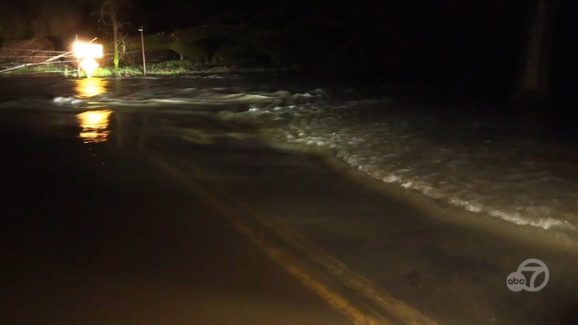
9:45 p.m. Flooding prompts road closures in parts of Marin County, officials say
A portion of state Highway 1 in Marin County closed Sunday night due to flooding, the county office of emergency management said at 8:45 p.m.
Flooding has closed Highway 1, also known as Shoreline Highway, south of Tomales Petaluma Road and north of Snake Road near Tomales in northwest Marin, the county said.
5 p.m. 'Another round': Powerful storm hitting the Bay Area with strong winds and rain

The Bay Area remains on storm watch this weekend and many are bracing for round two of heavy rain and winds. For those living on the coast, there's a warning about high surf.
"Wow, look at the swells building up. That's going to hit 15 or 20 feet," said Janaki Tenneti.
Tenneti and her husband Rama are watching big waves crashing at the Pacifica Pier. The surf is churning up ahead of the next storm moving into the Bay Area.
"Oh, it's magnificent. It's exhilarating to see the high swells," said Janaki Tenneti.
"It's amazing, scary too. I felt dizzy when I was watching the waves, because they keep moving," said Rama Tenneti.
The city is closing the Municipal Pier to the public as a safety precaution due to high wave action. A sign is posted.
Neighbors on Beach Boulevard are sandbagging their properties, to keep seawater out.
Stormy conditions have prompted the closure of seven parks in San Mateo County, including San Pedro Valley Park in Pacifica. Officials are concerned about trees toppling.
"Well, for safety reasons, that's a good thing. Today is less windy than yesterday. We came into the park for a walk but turned around at a specific time," said Lynn Mullen from Pacifica.
In the North Bay, a big tree fell Saturday in downtown Santa Rosa on 4th street, knocking out power to some businesses.
And several roads in Sonoma County, near the Russian River, saw weekend flooding. First responders say they're ready for more of the same.
"We've spent the last few days reaching out to our community, making sure they know the potential of another round of rain and the effects like we saw earlier this month, and the potential for flooding, outages and slow traffic conditions," said Santa Rosa Fire Marshal Paul Lowenthal.
3 p.m. Vallejo opens warming center amid Bay Area storm
The City of Vallejo will open its warming center Sunday night until Wednesday morning in anticipation of the coming storm.
The warming center will be open 7 p.m. to 6 a.m. each day and is located in the Vallejo Room of the JFK Library, at 505 Santa Clara Street, in Vallejo.
The city is seeking volunteers to help with the warming center through Wednesday morning. If interested, click here for more info.
For further inquiries, please email homelessness@cityofvallejo.net.
2 p.m. Bay Area under flood watch, NWS says
The National Weather Service said just after 1:30 p.m. Sunday that a flood watch is in effect for most of Northern California through Wednesday morning.
Forecasters said to expect periods of moderate to heavy rain, as well as brief heavy showers from thunderstorms, beginning later Sunday afternoon and continuing through Tuesday.
The NWS said valley and Delta areas can expect 1.5 to 3 inches of rain and foothill areas 2.5 to 5 inches of rain.
Coastal and low-lying areas should expect nuisance flooding and residents living near rivers, creeks and streams should be aware of rising water levels.
There will also be a possibility of rock and mudslides in foothill areas.
The NWS says people should never drive across flooded roads and have an evacuation plan and an emergency kit.
1 p.m. Brief tornadoes, hail and thunderstorms possible in eastern part of East Bay Monday, NWS says
The National Weather Service said around 12:15 p.m. Sunday that brief tornadoes, hail and thunderstorms are possible in the Central Valley and the eastern part of the East Bay Area on Monday.
The NWS said there's a 30% to 50% chance of severe thunderstorms hitting the area Monday afternoon and evening, "Make sure you have multiple ways of receiving weather alerts," the NWS said on social media.
Residents can also expect gusty winds. The rain is expected to begin Sunday afternoon.
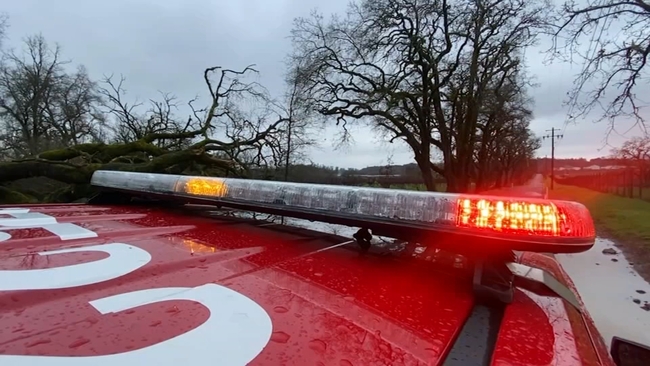
7 a.m.: Large tree falls in Santa Rosa causing power outage
In the North Bay, a large tree came down in Santa Rosa in the downtown area of Fourth Street causing a power outage.
Firefighters showed up and cleared the tree within an hour.
They're warning people when power lines come down, treat those power lines as if they're energized and call 911.

SATURDAY
6:30 p.m.: Several San Mateo Co. parks closed due to weather, officials say
Seven San Mateo County parks were closed Saturday due to high winds, the county parks department said.
The parks will be closed until conditions are safe, the department said in a social media post.
The closures came as the National Weather Service issued a wind advisory Saturday for the Bay Area and Central Coast.
South winds of 25 mph to 35 mph, with gusts up to 50 mph, were forecast from 10 a.m. Sunday to 4 a.m. Tuesday.
The parks that were closed are:
- Devil's Slide Trail
- Quarry Park
- Fitzgerald Marine Reserve
- San Pedro Valley
- Pillar Point Bluff
- Mirada Surf
- Moss Beach Park
6 p.m.: North Bay first responders gearing up for storms through Monday
The Bay Area is bracing for the storms this holiday weekend, which are expected to bring strong winds, heavy rain and possible flooding. First responders say they're ready for whatever comes.
The Gold Ridge Swift Water Rescue team fired a rope gun across the Russian River Saturday. The team is running practice drills with swimmers ahead of strong back-to-back storms which could raise river levels significantly higher.
This team is now activated and ready for the real thing if the call comes.
"We don't practice on the public. It's imperative we're experts at our jobs before the emergency happens," said Gold Ridge Fire Battalion Chief Gino Degraffenreid.
By late morning, rain started falling in Sonoma County. The storms bring a threat of flooding. It's why several roads in the Russian River Valley are being closed, like Mark West Station Road, where firefighters rescued a driver two weeks ago, after they ignored barricades and flooded signs.
"We'll definitely be making a presence, making sure people are obeying the rules, not going through barricades because they will be fined, said Ryan Osborne from Sonoma County Fire District.
Sonoma County Fire activated its Emergency Operations Center, where real-time data and weather forecasts are being reviewed and relayed to crews responding to emergencies.
"We are looking at strong winds causing trees to come down, power lines down, looking at a very heavy rainfall probability, going to be dealing with roads flooded," said Mark Heine from Sonoma County Fire District.
In Petaluma, umbrellas were up. We found Emerson Rahimian pulling a wagon, selling Girl Scout cookies in the rain.
3 p.m.: Santa Cruz Co. activates emergency warming center ahead of storm
Santa Cruz County has activated emergency warming shelters ahead of the flood watch and high wind advisory for Sunday through Tuesday.
The temporary protective severe weather shelters will open at three locations: the Santa Cruz Veterans Hall on 846 Front Street, Depot Park at 119 Center Street in Santa Cruz and Watsonville Veterans Hall on 215 East Beach Street in Watsonville.
The shelter system is the result of a joint effort involving the County of Santa Cruz, the City of Santa Cruz and the City of Watsonville.
Depot Park and Watsonville Veterans Hall will operate as 24-hour shelters, starting at 12 noon on Sunday, Feb. 18, and be open until noon on Tuesday, Feb. 20. Shelter at the Santa Cruz Veterans Hall will operate as an overnight shelter from 8 p.m.-8 a.m. on Feb. 18 and 19, and from 10 p.m.-7 a.m. on Feb. 20. Reassessment for continuing shelter operations will take place on Tuesday.
Beds will be offered based on a first-come, first-served basis, with priority given to those with disabilities and experiencing notable health or safety risks while sleeping outdoors.
Cots, blankets and ready-to-eat meals will be provided. Food will be available after intake and bed allocations have been finalized. Pets will only be allowed if they are leashed and kept under voice control. No aggressive animals will be permitted inside.
Personal belongings must fit into small storage spaces located near assigned beds.
Lineup for shelter services starts one hour before the shelters open. Space is limited.
Bay City News contributed to this report.