San Francisco reaches 100 degrees, more than 10 Bay Area cities smash record-high temps


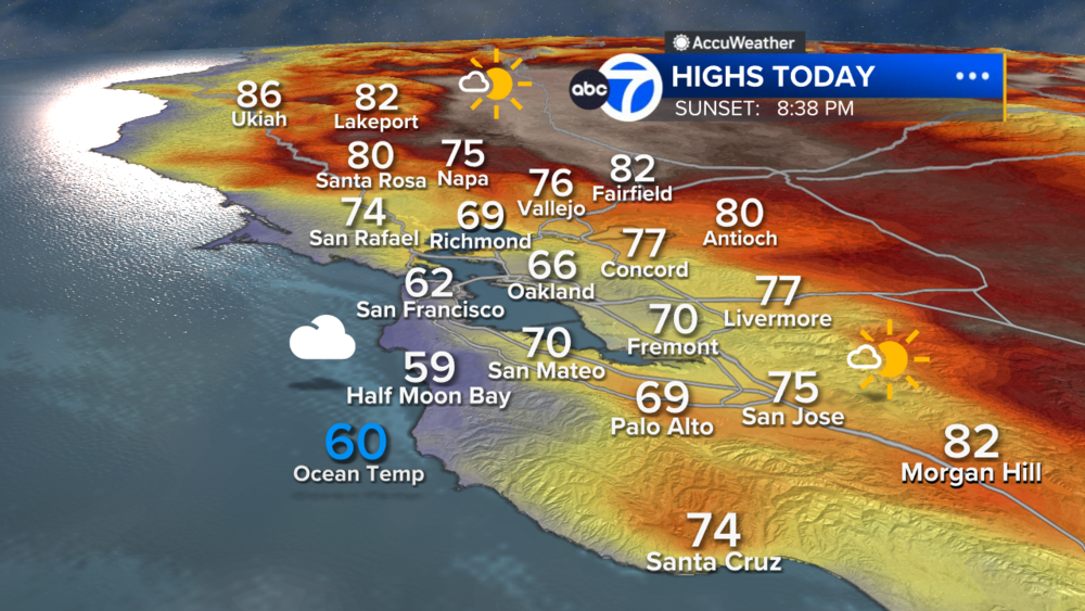
SAN FRANCISCO (KGO) -- Records were smashed all across the Bay Area Sunday as a heat wave impacting millions of Californians intensified. More than 10 cities in the Bay Area set new records.
San Francisco hit 100 degrees for the 1st time since 2017. Concord, Livermore, Gilroy, Napa and Santa Rosa had high temperatures between 110 and 112, all records for this date.
RELATED: Here's where you can stay cool in Santa Clara County amid incoming heat wave
As our heat wave continues for the Labor Day holiday Monday, our fire danger will be increasing. Gusty offshore winds are forecast to develop late Monday night into Tuesday.
A Red Flag Warning has been issued for the North Bay Mountains, East Bay Hills and the Santa Cruz Mountains as winds could gust over 45mph, especially Tuesday morning.
RELATED: Without energy conservation, rotating power outages 'expected' amid dangerous heat wave, CA ISO says
These gusty winds will also bring very low humidity. Combine that with the hot temperatures from the heat wave, vegetation is ripe for new fires to start or current fires to spread.
Winds are forecast to relax Wednesday morning.